Spacc BBS Spacc BBS
    • Categorie
    • Recenti
    • Tag
    • Popolare
    • Mondo
    • Utenti
    • Gruppi
    • Registrati
    • Accedi
    La nuova BBS è in fase Alpha. I post precedenti al 22 luglio 2024 potrebbero non essere trasferibili, ma rimarranno disponibili per la lettura su /old/.

    I'd like to print a big map of Hamburg in DIN A0 format, based on #openstreetmap data!

    Pianificato Fissato Bloccato Spostato Uncategorized
    openstreetmap
    23 Post 4 Autori 22 Visualizzazioni
    Caricamento altri post
    • Da Vecchi a Nuovi
    • Da Nuovi a Vecchi
    • Più Voti
    Rispondi
    • Topic risposta
    Effettua l'accesso per rispondere
    Questa discussione è stata eliminata. Solo gli utenti con diritti di gestione possono vederla.
    • blinry@chaos.socialB Questo utente è esterno a questo forum
      blinry@chaos.social @blinry@chaos.social
      ultima modifica di

      They told me yesterday to send them the file via their web upload – not sure what kind of difference that makes? The PC that couldn't open the file seemed more like a "USB stick handling terminal", so I guess they have more powerful computers in the back…

      Anyway, they just told me I could fetch the poster in half an hour! \o/

      blinry@chaos.socialB 1 Risposta Ultima Risposta Rispondi Cita 0
      • blinry@chaos.socialB Questo utente è esterno a questo forum
        blinry@chaos.social @blinry@chaos.social
        ultima modifica di

        Some more options for making high-resolution #openstreetmap posters that I found:

        There are organizations providing high-resolution pre-rendered tiles in OSM's default "Carto" style, which I love! (osm.org's versions are too low-resolution for printing.

        Many are commercial (but often have a "free tier", which should be sufficient). The best one I found is https://maps.lima-labs.com (they seem to use the "German" Carto fork, which highlights the Autobahn…)

        blinry@chaos.socialB 1 Risposta Ultima Risposta Rispondi Cita 1 0
        • blinry@chaos.socialB Questo utente è esterno a questo forum
          blinry@chaos.social @blinry@chaos.social
          ultima modifica di

          And there's the data center of the University of Erlangen–Nuremberg, which also provide free high-resolution tiles in the Carto style!

          They're mostly intended for internal use, but they permit low-volume external use, as well. If you go this route, please make sure to crawl the necessary tiles slowly. <3

          RRZE Openstreetmap-Server

          favicon

          (osm.rrze.fau.de)

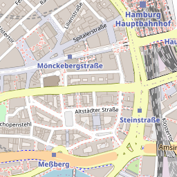
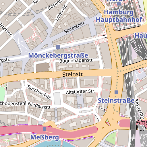
          Here's a comparison of osm.org's tiles, and the RRZE tiles:

          Link Preview ImageLink Preview Image
          blinry@chaos.socialB 1 Risposta Ultima Risposta Rispondi Cita 1 0
          • blinry@chaos.socialB Questo utente è esterno a questo forum
            blinry@chaos.social @blinry@chaos.social
            ultima modifica di

            Using one of these tile providers, you could use two approaches to make them into a large-scale map:

            You could have https://bigmap.osmz.ru generate a Python script for bulk download, and swap in another URL to download from.

            Or you could create a source for them in https://qgis.org (a desktop map-rendering application). This makes it pretty convenient to generate a print file in the correct map scale, as well! (Not sure how to do rate limiting there?)

            blinry@chaos.socialB 1 Risposta Ultima Risposta Rispondi Cita 1 0
            • blinry@chaos.socialB Questo utente è esterno a questo forum
              blinry@chaos.social @blinry@chaos.social
              ultima modifica di

              Second option: Vector tiles! https://openfreemap.org is a community-made free source that I found. You can also load them into QGIS easily. (Caveat: Seems to use English labels?)

              They need to be rendered client-side, though, so you need a good style definition. The best one I found is the one that comes with the MapTiler QGIS plugin: https://github.com/maptiler/qgis-maptiler-plugin (It's open source, even if their data source is not free, but you can copy the style to the OpenFreeMap source).

              blinry@chaos.socialB 1 Risposta Ultima Risposta Rispondi Cita 0
              • blinry@chaos.socialB Questo utente è esterno a questo forum
                blinry@chaos.social @blinry@chaos.social
                ultima modifica di

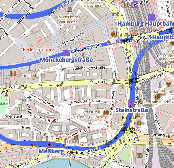
                One very nice thing about this vector-based approach is that you can *change* the style definitions to your liking! For example, here's an example where I tried to highlight the subway lines more (for a similar region than the raster tiles a couple of toots ago):

                To be honest, I think the quality and attention to detail in the raster Carto style is hard to replicate, though. Would require some additional tweaking to make me happy. But QGIS can now export this to a crisp PDF!

                Link Preview Image
                blinry@chaos.socialB gustavinobevilacqua@mastodon.cisti.orgG 2 Risposte Ultima Risposta Rispondi Cita 0
                • blinry@chaos.socialB Questo utente è esterno a questo forum
                  blinry@chaos.social @blinry@chaos.social
                  ultima modifica di

                  For my poster, I used http://printmaps-osm.de, which I still think is a good, low-hassle option, if your desired size is not larger than something like A0 or double-A0, and if you're happy with the default style. It even has a couple of different styles to pick from.

                  1 Risposta Ultima Risposta Rispondi Cita 1 0
                  • blinry@chaos.socialB Questo utente è esterno a questo forum
                    blinry@chaos.social @blinry@chaos.social
                    ultima modifica di

                    It's here!! ✨ Love it!

                    Link Preview Image
                    gustavinobevilacqua@mastodon.cisti.orgG 1 Risposta Ultima Risposta Rispondi Cita 1 0
                    • gustavinobevilacqua@mastodon.cisti.orgG Questo utente è esterno a questo forum
                      gustavinobevilacqua@mastodon.cisti.org @blinry@chaos.social
                      ultima modifica di

                      @blinry

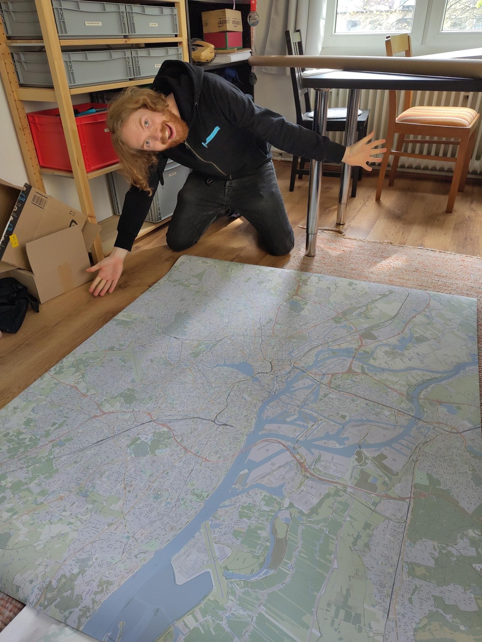
                      WTF… "Museum der Illusionen"???

                      I have to visit it!

                      Link Preview Image
                      Museum of Illusions Hamburg

                      Enter the world of fascinating illusions by paying a visit to Museum of Illusions Hamburg, an edutaiment museum concept ideal for all ages.

                      favicon

                      Museum of Illusions Hamburg (hamburg.museumderillusionen.de)

                      1 Risposta Ultima Risposta Rispondi Cita 0
                      • gustavinobevilacqua@mastodon.cisti.orgG Questo utente è esterno a questo forum
                        gustavinobevilacqua@mastodon.cisti.org @blinry@chaos.social
                        ultima modifica di

                        @blinry

                        And now the hardest part: to find a frame for it!
                        😄

                        1 Risposta Ultima Risposta Rispondi Cita 0
                        • dunpiteog@devianze.cityD dunpiteog@devianze.city shared this topic on
                        • Primo post
                          Ultimo post